He aha ngā Pūnaha Hauropi?
What is an ecosystem?
Understand how the diversity, distribution and threat status of ecosystems in Tāmaki Makaurau / Auckland is important in protecting and enhancing our biodiversity.
Ecosystems explained
An ecosystem is a biological community of interacting organisms and their physical environment.
Ecosystems are defined by how unique they are within a set area. This includes what is living there and the type of environment.
Ecosystems may vary in size from small wetlands to large tracts of forest.
Understanding ecosystems in Tāmaki Makaurau / Auckland is important for:
- the protection and enhancement of biodiversity
- informing ecological restoration
- state of the environment reporting.
Information about which ecosystems occur in Tāmaki Makaurau, their location and condition, helps determine priorities for biodiversity management and land-use decisions.
Classification of ecosystems
A national classification system describes the full range of indigenous ecosystem types that occur in Aotearoa / New Zealand on a variety of scales.
The Auckland Council indigenous terrestrial and wetland ecosystems of Auckland guide uses a subset of the national classification ecosystem descriptions. In most cases the descriptions will apply nationwide, however many have been adapted and expanded to describe the character within Tāmaki Makaurau.
Some sites in Tāmaki Makaurau may be classified as an ecosystem for which the description is not an exact match. In other cases, some sites may support novel (new) or hybrid (mixed) ecosystems. This happens when either one or both of the following occur:
- human influence has caused irreversible environmental change
- non-native species have invaded.
Mapping our ecosystems
Over the last few hundred years, there have been significant changes to the structure, composition and function of the indigenous terrestrial and wetland ecosystems of Tāmaki Makaurau. There has also been a reduction in the natural extent of most ecosystems.
The process of mapping the current extent of Tāmaki Makaurau's terrestrial and wetland ecosystems has involved collating data and information from a variety of sources including historic surveys. Further ecological surveys were carried out for approximately 2000 sites to fill knowledge gaps and to update some of the existing data.
The resulting data was compiled into a single geospatial (digital mapping) layer. Auckland Council will continue to refine the current ecosystem layer as new survey work occurs.
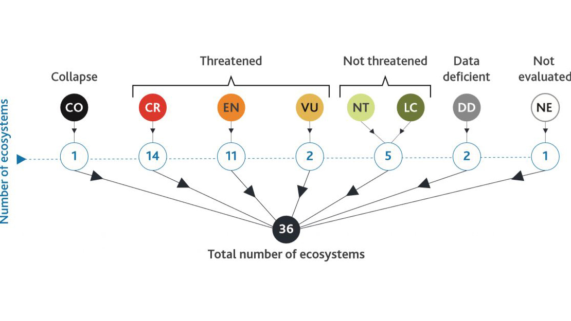
Threatened ecosystems and risk categories
Many ecosystem types in Tāmaki Makaurau have been reduced from pre-human times to less than 10 per cent of their original extent. Others are considered to have been naturally uncommon.
A thorough threatened ecosystem risk assessment was completed to:
- identify which of the region’s ecosystems are threatened
- help prioritise protection, management and restoration.
Almost 40 per cent Auckland's terrestrial and wetland ecosystems have been identified as Critically Endangered. This is the result of extensive historical clearance of indigenous vegetation.
The ecosystems were assessed into eight risk categories for each ecosystem. These categories are:
- Collapse (equivalent of the extinct category for species)
- Critically Endangered
- Endangered
- Vulnerable
- Near Threatened (almost meet the criteria for Vulnerable)
- Least Concern (meet none of the criteria)
- Data Deficient (too little data exists)
- Not Evaluated (not yet been assessed)
Ecosystem descriptions
In Auckland, there are nine ecosystem units that represent the main zonal and azonal ecosystems found in the region.
Detailed descriptions for each ecosystem include:
- its abiotic (physical) processes
- national and Auckland regional distribution
- characteristic native flora and fauna
- key processes and interactions
- threats.
The ecosystem unit descriptions and code abbreviations are:
- AVS: human influenced
- WF: warm forests
- MF: mild forests
- WL: wetlands
- DN: active coastal sand dunes
- CL: cliffs
- SA: saline
- GT: geothermal
- CV: cave
- VS: vegetation succession (regenerating ecosystems).