Karekare Stream
Size: 0.8 hectares
Area description
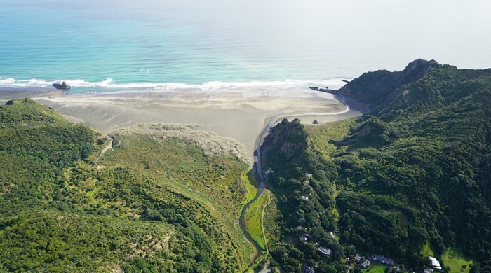
This biodiversity focus area is situated within Waitākere Ranges Regional Park. It sits on the margins of Karekare Stream before the stream flows onto Karekare Beach.
The vegetation is dominated by pūrua grass on both sides of the stream in the black west coast sands. It transitions into the Karekare sand dunes on the southern side of the stream. The northern side is dominated by pōhutukawa growing on the coastal cliffs.
A public boardwalk extends through the northern section, connecting the public carpark to the surf club and beach.
Key ecosystem
This area has a good example of the oioi, restiad rushland and reedland (WL10) ecosystem type. This ecosystem is common in the freshwater parts of estuaries, coastal stream margins and in some inland areas near lakes.
It is an ecosystem much reduced from its original extent due to land-use impacts from urban development, conversion to agriculture and more. It has a regional threat ranking of Endangered.
Species
Species that are commonly found in this ecosystem type include:
- oioi
- pūrua grass
- kuta
- lake clubrush
Pūrua grass is the dominant species at this location. Water milfoil, a native herb which grows mostly in the water, grows on the edge of the usually slow-moving Karekare Stream.